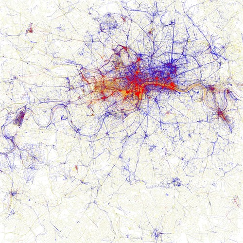
[A map of tourist and local hotspots in London as created by Eric Fischer]
If your travel resolution for 2011 is to see more than the standard tourist fare on your next trek, or to never take a photo of something you might see on a postcard, then this set of maps should definitely be part of your pre-flight checklist. Last May, Eric Fischer, an amateur photographer and data hound from Oakland, California, engineered an ingenious way to map out the locals-only nooks and crannies in some of the world's most photographed cities.
Fisher sifted six years of Flickr and Picasa postings into those that had been snapped by tourists (shutterbugs who flitted around the town for a month or less) and those that were the work of locals (folks with a longer photo history). Plotting the geotag info from the images, with tourist zones in red and local hot spots in blue, resulted in a one-of-a-kind tool for telling which neighborhoods are out-of-the-way gems and which are destination clichés.
As Fisher says, "in most cities there are places that are of interest to many people but are only really known to locals." But without a metro area native to tip you off, finding the hidden treasures that guidebooks overlook can be a challenge. Now you can look to the blue colored clusters on his maps as pretty good starting points.
So far, Fisher has mapped 126 cities on six continents (sorry, no Antarctica map yet), but if your itinerary doesn't pass through these locales, don't fret. He's always adding more, and responds to requests. Just drop him a note in the comments thread or by Flickr mail.
--Brad Scriber, Senior Researcher, National Geographic Magazine
Backlink: http://blogs.nationalgeographic.com/blogs/intelligenttravel/2011/01/an-avoidthetourists-map.html

No comments:
Post a Comment