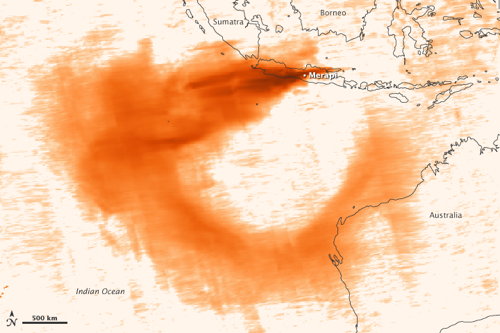
This image maps sulphur dioxide emissions from the erupting Mount Merapi volcano in Indonesia: “This image shows concentrations of sulfur dioxide on November 4–8, 2010, as observed by the Ozone Monitoring Instrument (OMI) on NASA’s Aura spacecraft. Sulfur dioxide is measured here in Dobson Units: The greatest concentrations appear in dark red-brown; the lowest in light peach.”
Sulfur Dioxide from Mount Merapi first appeared on The Map Room: A Weblog About Maps on November 10, 2010. Copyright © 2010 Jonathan Crowe. Distributed under a Creative Commons licence.
Post originale: http://www.mcwetboy.net/maproom/2010/11/sulfur_dioxide.php
No comments:
Post a Comment